
For months, meteorologists have been tracking the development of El Niño, warning that this year’s event could be one of the strongest on record. While the Pacific remains in an ENSO-neutral state for now, new satellite data suggests the transition to El Niño is imminent.
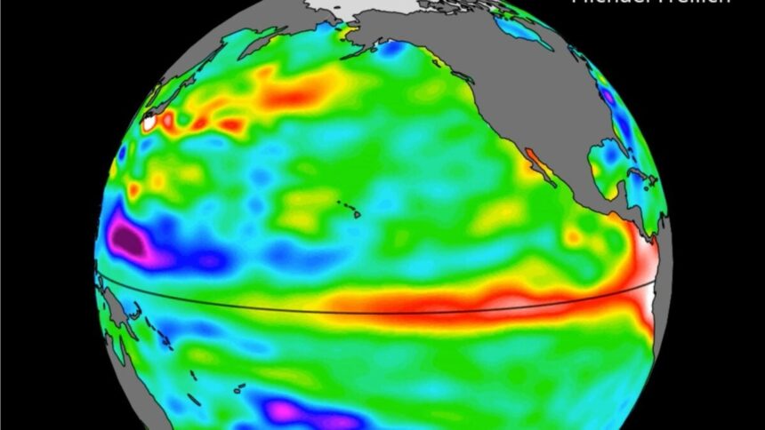
Sea level measurements taken by the Sentinel-6 Michael Freilich satellite, developed in partnership between several American and European agencies, show higher, warmer water moving eastward across the Pacific Ocean. You can see this phenomenon—known as a warm Kelvin wave—in the animation below, signified as a white, red, orange, and yellow blob tracking east along the equator. This pulse of warm water is a well-known precursor to El Niño.
The wave shown in the animation emerged in early March and reached the northwestern coast of South America in May. According to NASA, satellite data indicates that the waters around Peru were more than 5.9 inches (15 centimeters) higher than the long-term average by mid-May. Because water expands as it warms, this increase in sea surface height indicates an increase in sea surface temperature.
The data comes as meteorological agencies grow increasingly confident that El Niño will take hold within the next several weeks. This is the warm phase of the El Niño-Southern Oscillation (ENSO), a recurring climate pattern that has enormous influence over global temperatures and weather patterns. The latest report from the United Nations’ World Meteorological Organization urges nations to prepare for a “potentially strong” event, which would significantly increase the risk of extreme storms, flooding, droughts, and heatwaves.
Here it comes
Over the past several weeks, model projections for the severity of this developing El Niño have grown increasingly damning. As of early May, worst-case scenarios showed Pacific sea surface temperatures rising nearly 7 degrees Fahrenheit (4 degrees Celsius) above average—well past the threshold for a “very strong” El Niño. As such, some experts have begun referring to this potential event as a “super” El Niño.
The intensity of the observed Kelvin wave underscores just how severe the 2026-2027 El Niño could be. In mid-May, meteorologist Ben Noll reported that the wave was carrying ocean waters that had reached 13.5 degrees F (7.5 degrees C) above average in parts of the deep ocean. As that warm subsurface water tracks east, it suppresses upwelling, preventing deep, cold water from rising to the surface. This causes sea surface temperatures to rise rapidly, ushering in El Niño.
During this phase of the ENSO cycle, extraneous heat at the sea surface alters atmospheric circulation, leading to major shifts in global weather patterns. Stronger El Niño events lead to more drastic weather impacts because the Pacific offloads more heat into the atmosphere.
Noll and other meteorologists have compared the current Kelvin wave to the one that preceded the super El Niño of 1997-1998. By one estimate, that event led to $5.7 trillion in global income losses due to extreme weather. Today, El Niño events unfold within a climate system influenced by higher greenhouse gas concentrations, amplifying the weather impacts associated with this naturally occurring phenomenon.
While the full force of this event remains to be seen, all the ingredients for a super El Niño appear to be on the table. As meteorologists continue to monitor conditions in the Pacific, they are already urging decision-makers and the public to prepare for hazardous weather extremes.
Read the full article here