

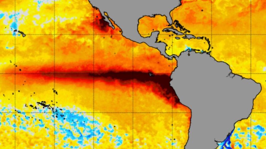
For months now, meteorologists and climate scientists have been warning that the strongest El Niño on record is coming. The latest model forecasts have convinced many that this historic event is all but certain, and now, it looks imminent.
Meteorologist Ben Noll reported Tuesday that sea surface temperatures in the Niño-3.4 region, an area of the central-eastern equatorial Pacific Ocean that serves as the main benchmark for El Niño and La Niña, have climbed 5.4 degrees Fahrenheit (3 degrees Celsius) above average. They are now just 0.36 degrees F (0.2 degrees C) away from breaking the all-time record, according to Noll.
The key El Niño monitoring region, Niño 3.4, has reached 3°C above average and is just 0.02°C from the all-time record.
This event is now on the verge of becoming the strongest El Niño ever recorded. pic.twitter.com/Zd3PfLS5Q3
— Ben Noll (@BenNollWeather) September 16, 2026
It’s worth noting that this event will reach historic strength months ahead of its expected peak. The latest prediction from the European Centre for Medium-Range Weather Forecasts (ECMWF) shows sea surface temperatures in the Niño-3.4 region peaking at around 7.2 degrees F (4 degrees C) above average in December.
On Thursday, the National Oceanic and Atmospheric Administration (NOAA) said there is a 75% chance of “a historic event that would exceed the strength of previous El Niño events dating back to 1950,” when record keeping began.
What ‘record strength’ really means
As a reminder, El Niño is the warm phase of the El Niño-Southern Oscillation (ENSO), the biggest year-to-year climate variation on the planet. During El Niño, sea surface temperatures in the central and eastern equatorial Pacific rise above average.
Excess heat emanating from this part of the ocean boosts Earth’s average temperature and shifts weather patterns across the globe. The stronger the El Niño, the more likely we are to feel these impacts. In the U.S., El Niño has historically led to wetter and cooler weather across the southern tier and warmer, dryer conditions across the northern tier.
One of the most classic signatures of El Niño—a suppressed Atlantic hurricane season and amped-up Pacific hurricane season—is already playing out. As of today, zero hurricanes have formed in the Atlantic basin this year, breaking a 60-year record for the longest stretch without one. If none form by Thursday—and it certainly doesn’t look like one will—this Atlantic hurricane season will break a 175-year record.
Meanwhile, the Pacific basin has been buzzing with cyclones. The eastern part of the basin has produced 14 named storms so far this year, including two hurricanes and three major hurricanes. That’s well above average.
With all that said, every El Niño manifests differently, and the outcome of this one is particularly difficult to predict given its unprecedented strength. Neither scientists nor climate models have ever seen an event like this one before. What’s more, this El Niño is unfolding against the backdrop of human-driven climate change, which could lead to unexpected impacts.
What is certain—especially given the combined impact of El Niño and climate change—is that this event will raise global temperatures, likely making 2026 the hottest year on record. Experts don’t think that record will hold for long, as El Niño’s biggest impact on global temperatures will arrive in 2027.
It likely won’t be long before the strongest El Niño ever observed is here, and experts say there’s good reason to be concerned about its effects. Many scientists have said this event will offer a taste of what Earth’s climate will look like permanently a decade from now without aggressive reductions in global carbon emissions.
Read the full article here