
So far, this winter has been characterized by bitterly cold temperatures in the East and a record-breaking snow drought in the West. This persistent pattern has brought major challenges to both regions, but now, it looks like it’s finally about to flip.
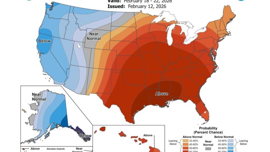
The National Weather Service’s Climate Prediction Center expects below-average temperatures for much of the West over the next six to 10 days. According to Drought.gov, a widespread and active precipitation pattern will move into the region over the next five days, bringing some much-needed snow to the far West. Meanwhile, the Central and Eastern U.S. will see a major warmup, with above-average temperatures stretching from Texas to Maine.
This is a major reversal from January, when the East battled back-to-back winter storms while the West’s snowpack remained critically low. The upcoming pattern flip will feel dramatic—here’s what to expect.
Winter reaches the West at last
An atmospheric river—a concentrated band of moisture in the lower atmosphere—already brought rain and mountain snow to parts of the West this week, according to NOAA. Now, the NWS is tracking a storm front moving from the Gulf of Alaska into the Pacific Northwest.
Parts of the western U.S. got some much-needed rain and mountain snow this week as a potent system swept in from the Pacific. @NOAA‘s #GOESWest (#GOES18) 🛰️ tracked the long plume of atmospheric moisture with its #WaterVapor channel yesterday.
Latest forecast:… pic.twitter.com/vPLESCAnt3
— NOAA Satellites (@NOAASatellites) February 12, 2026
This system should bring light to moderate snow to higher elevations across the region and the Interior West from Friday through Sunday. As it tracks southeast down the coast, snowfall chances will increase in Northern California’s higher elevations.
According to snow-forecast.com, the Pacific Northwest can expect widespread snow accumulations of up to 4 inches (10 cm) and 4 to 10 inches (10 to 25 cm) of mountain snowfall. The highest elevations could receive up to 20 inches (51 cm). California, meanwhile, is bracing for a much heavier impact.
The Golden State may get walloped by its coldest storm starting Sunday, according to The Weather Channel. This will majorly boost snowpack in the Sierra Nevada mountains, which could receive up to 5 feet (1.5 meters) of accumulation in certain areas. At lower elevations, forecasters expect heavy precipitation to primarily fall as rain, increasing the risk of flooding.
Flood danger will be especially high in areas affected by wildfire earlier this year, but this storm could be a good sign for the upcoming fire season. The West relies on mountain snowpack as its primary water source—springtime snowmelt plays an essential role in combating summer drought and fire conditions.
An early spring for the East
While the West bundles up, people across the East will be stuffing their heavy winter coats back in the closet. Widespread above-average temperatures will bring a taste of spring to more than half of the country next week as a warm front spreads eastward from the Plains to the Atlantic Coast.
It will be especially balmy across the Central U.S., where temperatures will be 15 to 30 degrees Fahrenheit (8 to 16 degrees Celsius) above normal, according to the NWS. From the central-southern Plains to the Southeast, highs will be in the 60s to 70s Fahrenheit (teens to low 20s Celsius), with some parts of Texas hitting the low 80s Fahrenheit (high 20s Celsius).
The Northeast will mostly see close-to-normal temperatures in the 30s and 40s Fahrenheit (single digit temperatures Celsius), but that will still feel significantly warmer than the life-threatening cold that lingered throughout January.
Overall, this nationwide pattern flip will be a welcome change for both the East and the West as this wild winter nears its end. With that said, the season isn’t over yet, and these long-range forecasts are subject to change. Don’t get too comfortable.
Read the full article here