
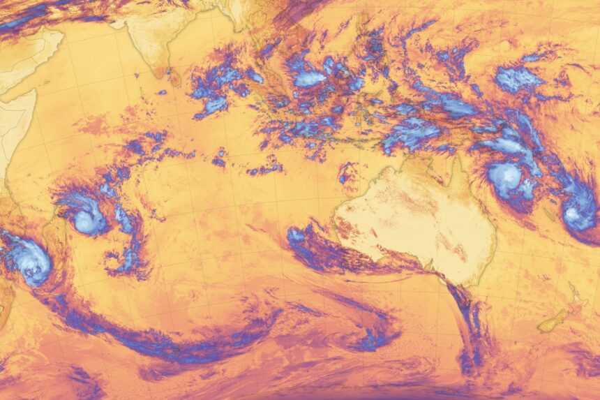
NASA satellite imagery captured tropical cyclones crowding the waters of two oceans in the Southern Hemisphere in recent days.
Three storms were simultaneously active in the Pacific Ocean—a rare event—but satellites also captured a trio of cyclones rolling across the Indian Ocean. The images reveal the intensity of the weather across a broad sweep of the Southern Hemisphere, and showcases the utility of agency satellites in tracking storm systems from low-Earth orbit.
The images were taken by the National Oceanic and Atmospheric Administration NOAA-20 using its Visible Infrared Imaging Radiometer Suite (VIIRS) sensor.
The Pacific storms are named Alfred and Seru, and the Indian Ocean systems are Bianca, Garance, and Honde. In the NASA false color imagery taken on February 26, Garance and Honde are seen toiling on either side of Madagascar, while Bianca sits off Australia’s west coast. Alfred and Seru are east of northern Australia.
According to a NASA Earth Observatory release, the image was taken a day after a sixth storm weakened too much to be identifiable in this shot. That storm brought heavy rain to Fiji.
But the other storms are still an imposing presence. Seru achieved Category 1 strength on the Saffir-Simpson scale—the go-to scale for measuring the strength of storms like hurricanes and cyclones. Alfred is seen in this image as a Category 2 storm, though February 27 (yesterday), the storm achieved Category 4 strength.
Tropical Cyclone Bianca is seen near the end of its life; it achieved Category 3 strength on February 25 but stayed far from land and dramatically weakened to a tropical storm the following day. But the other storms in the Indian Ocean, Garance and Honde, remain powerful systems that could be felt on land. Rain, strong winds, and storm surge remain in the forecast for Madagascar.
According to the NASA release, warm sea surface temperatures and weak wind shear may have given a platform for the storms. Indeed, warmer-than-average surface water temperatures in combination with low vertical wind shear also helped fuel Hurricane Milton last year, which intensified from a Category 1 storm into a Category 5 event in just 7 hours.
A marine heat wave has lingered in the waters west of Australia since September, and NOAA observed particularly high sea surface temperatures in the area this month. That said, ’tis the season for tropical cyclones, as the storms generally form between November and April in the southern hemisphere.
The satellite imagery is a reminder of the utility of spacecraft in monitoring climatological processes on Earth. Our measurements of the planet’s surface will only improve, as the NASA and Indian Space Research Organization (ISRO) mission NISAR is set to launch this year, and observe and measure changes to Earth’s surface with precision.
Read the full article here